Activating Columbia Road: Reframing a Missing Link
This report was guided by Field Projects, an Urban Planning practicum at Tufts University. The report was created in collaboration with team members: Xianzheng Fang, Marah Holland, Lev McCarthy, and Megan Morrow. Our team was partnered with LivableStreets Alliance to consolidate previous studies, recommendations, and outreach methods relating to Columbia Road. This was in effort to inform Livable Streets’ future community engagement along the corridor. It is our hope that the synthesis of current information, analyzed themes, and recommendations will ultimately help LivableStreets influence the city to prioritize action along this corridor.
Activating Columbia Road: Reframing a Missing Link was originally published on the Tufts Digital Library, openly available to all readers. A downloadable version of this report is available here: Activating Columbia Road: Reframing a Missing Link.
Executive Summary
Written by Megan Morrow
At first glance, Columbia Road appears to be a standard arterial road, running 2.4 miles through Dorchester and Roxbury, MA. However, its large width, high traffic, and sparse landscaping belie both its rich history and future potential. Home to several historic landmarks, including Boston’s oldest house, the Columbia Road corridor is bordered by several distinct neighborhoods and bookended by two large parks, Franklin Park and Moakley Park. Franklin Park is part of the Emerald Necklace, a series of parks designed in the late 19th century by Frederick Law Olmsted, known as the father of American landscape architecture. Olmsted envisioned that a verdant Columbia Road would serve as a key link in this network, yet this vision was never realized. Instead, Columbia Road was widened to host a major streetcar route through the 1950s before becoming the four-lane road it is today.
Inspired by this unfinished historical plan, the City of Boston, as well as several other planning, design, and advocacy organizations, has proposed projects to turn this vision of a greenway into a reality. LivableStreets Alliance (LSA), a nonprofit 501(c)(3) advocacy organization dedicated to improving transportation systems in the greater Boston region, is one such organization committed to helping the City of Boston realize this vision.
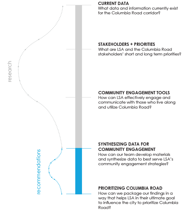
Rather than add to this wealth of existing information, our Field Projects team set out to consolidate previous studies, recommendations, and outreach methods in an effort to inform LSA’s future community engagement along the corridor. It was our hope that by synthesizing current information and analyzing themes across existing planning processes, we could ultimately help LSA influence the City to prioritize action along this corridor. Our research methods included conducting a literature review of existing conditions and five primary documents, holding semi-structured interviews with key contributors to each document, reviewing case studies, and performing related spatial analysis through GIS mapping.
The following primary documents were identified in partnership with LSA as the most comprehensive and relevant plans or projects relating to Columbia Road:
• Fairmount Indigo Planning Initiative: Corridor Plan
• Boston Green Links
• Go Boston 2030 Vision and Action Plan
• Fulfilling the Promise: Community Building and the Emerald Necklace
• Imagine Boston 2030: A Plan for the Future of Boston
These documents were produced by planning agencies, private firms, and community organizers. Each document identifies particular needs, visions, and goals for Columbia Road. Our team interviewed key contributors from each document to gain a deeper understanding of the planning processes and outcomes. Along with these documents, we reviewed three case studies of comparable projects. Lastly, our research explored how a redesign could benefit mobility, open space, public health, and placemaking. Columbia Road is an important transportation corridor, so we sought to emphasize mobility in a multi-modal analysis of walkability, pedestrian experience, bicycle infrastructure, bus access and use, commuter rail access and use, and car use and parking.
Following this research process our analysis revealed three major themes:
- Framing & Anchoring:
While the historic Olmsted connection is a big draw for architects and planners, it does not take into account current residents’ wants and needs. Similarly, the communities surrounding Columbia Road do not identify with the “Columbia Road corridor” as a distinct place or cohesive community.
- Siloed Interests and Agencies:
The separate jurisdictions and goals among city agencies, planning processes, adjacent neighborhoods, and community interests complicate the process of addressing such a geographically expansive and socially complex corridor like Columbia Road.
- Community Engagement:
The majority of the processes behind the primary documents included a community component. However, community engagement has yet to be done in a way that is corridor-wide, multi-lingual, and approachable for all residents.
These findings have lead us to make the following recommendations. First and foremost, we believe there is a need to demystify the idea of the Emerald Necklace and to reframe the purpose and motivations behind the Columbia Road project. We recommend moving away from this narrative and instead using community wants and needs to drive the decisions made for Columbia Road. Through a robust community engagement process, residents’ thoughts could provide a compelling, and more relevant, narrative for Columbia Road. Our research showed a significant opportunity to improve all modes of transportation along the corridor, as well as climate responsiveness, placemaking, and environmental health factors. We also recommend thoughtfully questioning the motives for this project before proceeding with any redesign of Columbia Road. Defining who this project is for, why it is important for the project to move forward, and how it should be framed will ensure that the redesign will serve the contemporary needs of the corridor rather than simply follow the trajectory of a historical plan.
Once the project is reframed, the engagement process can follow. In order to ensure that the project will serve the best interests of the surrounding neighborhoods, community engagement processes must work across neighborhood boundaries, within related planning processes, and in collaboration with multiple city departments. We recommend enhancing communication between planning projects, such as those for Franklin and Moakley Park, and integrating those projects into the community engagement process for Columbia Road. This includes working collaboratively with the MBTA to dispel concerns of competing transit modes.
Lastly, we recommend creating and using multilingual outreach materials for all community engagement activities, building relationships with trusted community stakeholders, and collaborating with key entities along the corridor to ensure that the project will meet the needs of people who currently live on or around Columbia Road. We believe this expanded scope, combined with a comprehensive engagement process, will provide the City with the public input and support needed to push this project toward implementation.
The factors that make the Columbia Road corridor a challenge to tackle – its history, diversity, high volume traffic, and sheer length – are the same factors that will make an eventual redesign that much more impactful. A redesign has the potential to improve mobility access, public health outcomes, climate resiliency, and open space access. Our team hopes that after years of related planning and conceptualizing, the City of Boston can use this synthesized report to reframe, reflect, and focus in on this project.
Final Report
Written by Aqsa Butt, Xianzheng Fang, Marah Holland, Lev McCarthy, and Megan Morrow.
 Previous Post
 Next Post