Placemaking for Spatial Justice: Suitability Analysis for Future Placemaking Along Columbia Road
This analysis was guided by GIS for Urban Analysis, a graduate course at Tufts University. The purpose of this analysis was to assess suitability for future placemaking along Columbia Road in Boston, Massachusetts.
Introduction
According to the paper, “Theorizing Critical Placemaking as a Tool for Reclaiming Public Space” by the American Journal of Community Psychology, the ability to access and participate in placemaking initiatives can transform community narratives and resist systems of oppression.1 Because placemaking interventions focus often on revitalization, there is the concern of displacement of marginalized communities and neglecting areas that are often subject to social and economic inequalities. Research, however, suggests that this could be challenged by promoting social inclusion and belonging in placemaking initiatives.2 According to Toolis, “environmental psychology literature on behavior settings, place identity, and place attachment demonstrates that place plays an active and co-constitutive role in shaping our sense of self, our behavior, and our relationships.” These concepts, “support the idea that engaging in the creation of public settings that are more bottom-up, inclusive, and participatory could in turn act as a pathway to changing the thoughts and actions of the people in that setting.”3
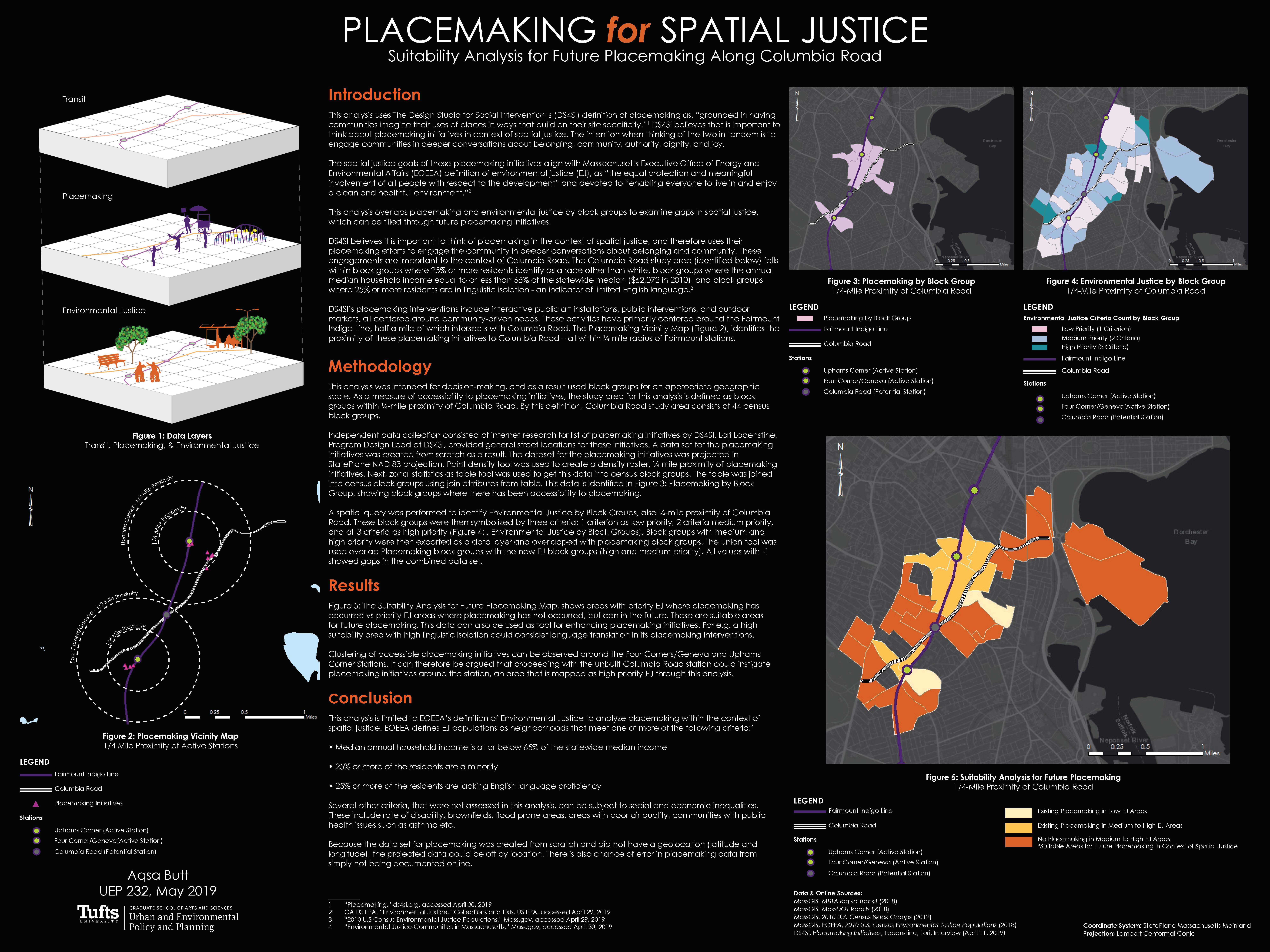
Design Studio for Social Intervention (DS4SI), an artistic research and development organization in Boston, Massachusetts, believes it is important to think of placemaking in the context of spatial justice, and therefore uses their placemaking efforts to engage the community in deeper conversations about belonging and community. These engagements are important to the context of Columbia Road as the Columbia Road study area falls within block groups where 25% or more residents identify as a race other than white, block groups where the annual median household income equal to or less than 65% of the statewide median ($62,072 in 2010), and block groups where 25% or more residents are in linguistic isolation – an indicator of limited English language.4
DS4SI’s placemaking interventions include interactive public art installations, public interventions, and outdoor markets, all centered around community-driven needs. These activities have primarily centered around the Fairmount Indigo Line, half a mile of which intersects with Columbia Road. The Placemaking Vicinity Map (Figure 2), identifies the proximity of these placemaking initiatives to Columbia Road – all within ¼ mile radius of Fairmount stations. According to the Fairmount Indigo Planning Initiative Corridor Plan, a Columbia Road station has been proposed on this line to increase transit access.5
This analysis uses DS4SI’s definition of placemaking as, “grounded in having communities imagine their uses of places in ways that build on their site specificity.”6 DS4SI believes that is important to think about placemaking initiatives in context of spatial justice. The intention when thinking of the two in tandem is to engage communities in deeper conversations about belonging, community, authority, dignity, and joy. The spatial justice goals of these placemaking initiatives align with Massachusetts Executive Office of Energy and Environmental Affairs (EOEEA) definition of environmental justice (EJ), as “the equal protection and meaningful involvement of all people with respect to the development” and devoted to “enabling everyone to live in and enjoy a clean and healthful environment.”7
Data Sources and Methodology
The methodology involves overlapping of placemaking and environmental justice by block groups to examine gaps in spatial justice, which can be filled through future placemaking initiatives. This analysis was intended for decision-making in future placemaking and as a result used block groups for an appropriate geographic scale. As a measure of accessibility to placemaking initiatives, the study area in this analysis is defined as block groups that fall within ¼-mile proximity of Columbia Road. By this definition, Columbia Road study area consists of 44 census block groups.
Data sources for this analysis include:
- MassGIS, MBTA Rapid Transit (2018)
- MassGIS, MassDOT Roads (2018)
- MassGIS, 2010 U.S. Census Block Groups (2012)
- MassGIS, EOEEA, 2010 U.S. Census Environmental Justice Populations (2018)
- DS4SI, Placemaking Initiatives
Independent data collection consisted of internet research for list of placemaking initiatives by DS4SI.8 Lori Lobenstine, Program Design Lead at DS4SI, provided general street locations for these initiatives. As a result, data set for placemaking initiatives was created from scratch. The dataset for the placemaking initiatives was projected in StatePlane NAD 83 projection. Point density tool was used to create a density raster, ¼ mile proximity of placemaking initiatives. Next, zonal statistics as table tool was used to get this data into census block groups. The table was joined into census block groups using join attributes from table functionality. This data is identified in Figure 3: Placemaking by Block Group, showing block groups where there has been accessibility to placemaking.
A spatial query was performed to identify Environmental Justice by Block Groups, also ¼-mile proximity of Columbia Road. These block groups were then symbolized by three criteria: 1 criterion as low priority, 2 criteria medium priority, and all 3 criteria as high priority (Figure 4: Environmental Justice by Block Groups). Block groups with medium and high priority were then exported as a data layer and overlapped with placemaking block groups. The union tool was used overlap Placemaking block groups with the new EJ block groups (high and medium priority). All values with -1 showed gaps in the combined data set.
Results and Conclusion
Figure 5: The Suitability Analysis for Future Placemaking Map, shows areas with priority EJ where placemaking has occurred vs priority EJ areas where placemaking has not occurred, but can in the future. These are suitable areas for future placemaking. This data can also be used as tool for enhancing placemaking initiatives. For e.g. a high suitability area with high linguistic isolation could consider language translation in its placemaking interventions.
Mobility plays a large role is placemaking. Mobility in transportation focuses predominantly on fixed physical infrastructures, such as the Fairmount Indigo Line, where there is a place of origin and destination (Upham’s Corner and Four Corners/Geneva Stations). Figure 5 shows gaps in placemaking initiatives around the unbuilt Columbia Road station. Since clustering of accessible placemaking initiatives can be observed around the Four Corners/Geneva and Uphams Corner Stations, it can be argued that proceeding with the unbuilt Columbia Road station could instigate placemaking initiatives, an area mapped as high priority EJ through this analysis.
Gaps, Limitations, and Sources of Error
This analysis is limited to EOEEA’s definition of Environmental Justice to analyze placemaking within the context of spatial justice. EOEEA defines EJ populations as neighborhoods that meet one of more of the following criteria:9
- Median annual household income is at or below 65% of the statewide median income
- 25% or more of the residents are a minority
- 25% or more of the residents are lacking English language proficiency
Intentional placemaking can and should be based on several other criteria that can be subject to social and economic inequalities. Social and economic inequities not assessed in this analysis include rate of disability, communities with public health issues such as asthma and poor air quality, brownfields, flood prone areas etc.
Because the data set for placemaking was created from scratch and did not have a geolocation (latitude and longitude), it was difficult to map the actual location of each initiative. The projected data in this map could be off by location. There is also chance of error in placemaking data from simply not being documented online.
1 Toolis, “Theorizing Critical Placemaking as a Tool for Reclaiming Public Space.”
2 Toolis.
3 Toolis.
4 Mass.gov, “Environmental Justice Communities in Massachusetts.”
5 Boston Redevelopment Authority, “Fairmount Indigo Planning Initiative – Corridor Plan.”
6 DS4SI, “Placemaking.”
7 OA US EPA, “Environmental Justice.”
8 DS4SI, “Placemaking.”
9 “Environmental Justice Communities in Massachusetts.”
References
“Environmental Justice Communities in Massachusetts,” Mass.gov, accessed April 30, 2019, https://www.mass.gov/info-details/environmental-justice-communities-in-massachusetts.
Erin E. Toolis, “Theorizing Critical Placemaking as a Tool for Reclaiming Public Space,” American Journal of Community Psychology; Macon 59, no. 1/2 (March 2017): 184–99, http://dx.doi.org.ezproxy.library.tufts.edu/10.1002/ajcp.12118.
“Fairmount Indigo Planning Initiative – Corridor Plan,” accessed May 8, 2019, http://www.bostonplans.org/getattachment/653f6e4d-a482-4163-ad39-11876d8f656a.
Lobenstine, Lori, April 11, 2019.
OA US EPA, “Environmental Justice,” Collections and Lists, US EPA, November 3, 2014, https://www.epa.gov/environmentaljustice.
“Placemaking,” ds4si, accessed April 30, 2019, https://www.ds4si.org/placemaking.

 Next Post
